


Visit Us
The Refuge is open year round, during daylight hours (gate on Lighthouse Rd. opens at 6 am). Entrance fee required.
The Refuge's Visitor Center and administrative office is located about 25 miles south of Tallahassee, FL. From Tallahassee, take SR 363 (Woodville Hwy) to Wakulla. Turn left (east) on SR 267 (Bloxham Cutoff). At US 98 (Coastal Hwy), turn left (east) and cross the St. Marks River. Turn right on Lighthouse Road (CR 59) and drive 3 miles to the Visitor Center/Office.
PO Box 68 (mail)
1255 Lighthouse Road (packages only)
St. Marks, FL 32355
[GPS: 30° 9.097' N 84° 8.845' W]
Late fall through early spring the weather is usually cool, with some afternoon showers. Summer is hot and humid with a variety of biting insects.
Administrative roads and levees may be closed during prescribed burns, peak wildlife events, especially around eagle nests, shorebird and waterfowl areas. Please check with the Visitor Center for the latest information concerning closures. +1 850-925-6121.
Food & Lodging – there is no place on the refuge to buy food or stay overnight, but picnic tables, drinking water and restrooms are available.
$1 per bike/pedestrian
$5 per vehicle
$25 for annual Refuge pass
Federal Recreation Fee (America the Beautiful) Passes are honored
Visitor Center (St. Marks Unit)
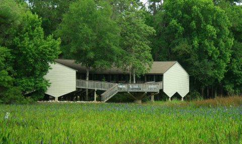
The Visitor Center is open Monday – Friday, 8 am – 4 pm; Saturday and Sunday, 10 am – 5 pm; closed Thanksgiving, Christmas, and New Year's Day and it may be closed on other Federal holidays. The Visitor Center exhibits, Nature Store, information desk, and restrooms, make this a perfect stop for first-time or repeat visitors. Federal Recreation Fee (America the Beautiful) Passes are available for purchase.
The Nature Store, located inside the Visitor Center, carries items that highlight the animals and plants of the Refuge; and all profits go to support Refuge programs and projects. The Nature Store is open on Friday, Saturday, and Sunday.
Restrooms are located inside the Visitor Center and at Tower Pond Trail. However, when our Visitors Center was completed in the early 1980s, our restrooms met the requirements at that time. In the intervening years, we have upgraded our entrance doors to automatic doors and built an all access trail and overlook. At this time, our restrooms are not fully compliant with the current standards and some visitors may have difficulty using them.
Nature's Classroom
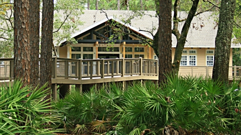
The Environmental Education Building, known as Nature's Classroom, was completed in September 2011. It contains 3200 sq. ft. and has one conference room, the Barred Owl Room, and one classroom, the Monarch Butterfly Room. Besides environmental education, Nature's Classroom is used for wildlife photography classes, and local and national conferences.
Nature's Classroom is located next door to the Visitor Center.
St. Marks Lighthouse
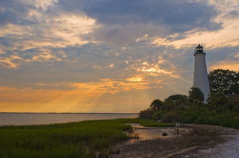
One of the most photographed landmarks on the Gulf coast, the St. Marks Lighthouse is the second oldest lighthouse in Florida and the oldest on the Gulf coast. It was the only lighthouse in Florida with wooden stairs. The current tower was completed in 1842.
Renovations to the keeper's house and tower were completed in 2017-18.
The keeper's quarters are open on Friday, Saturday, and Sunday from 11 am until 3 pm. Check with the Visitor Center for the latest schedule, +1 850-925-6121.
History of the St. Marks Lighthouse
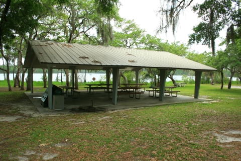
Otter Lake Recreational Area (Panacea Unit)
Daylight Use Only
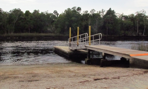
The Panacea Unit is largely dominated by uplands pine and oak forests, with several fresh water lakes interspersed. Primitive walking trails criss-cross through this unit, and like the Wakulla Unit, this unit is open to quota-hunts during the fall and winter months. Located within the Panacea Unit is the Otter Lake Recreation Area, which offers picnic shelters, restrooms, and a launching point for small boats (motor size limit of 10 horse power or less). Recreation Area located of US 98 in Panacea.
Use of picnic facilities, trails and launch point is free to the public.
Aucilla River Unit:
Located along the banks of the Aucilla River, this unique area features a boat ramp and plenty of fishing opportunities for visitors. This area is currently managed by Taylor County in a cooperative agreement with the U.S. Fish and Wildlife Service. The Aucilla River unit is located off US 98, approximately 15 miles east of the town of Newport. Taylor County collects a user fee at the Aucilla River/Mandalay boat ramp.
Wakulla Unit:
Daylight Use Only
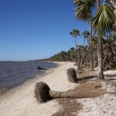
Located off US 98, west of the town of St. Marks, the Wakulla Unit of the wildlife refuge offers upland forests, palm hammocks, fresh and brackish water marshes and tidal beach access to the Apalachee Bay. This unit is open to quota-hunts during the fall and winter months, and it provides an ideal launching point for small boats year-round. Approximately 5.5 miles of the Florida National Scenic Trail traverses through this portion of the refuge including the popular hike through the "Cathedral of Palms" to Shepard Spring. No facilities. Use of launch point and access to trails are free to the public.
Flint Rock (Newport Hunt Area)
Daylight Use Only
Permitted:
- Photography (No Drones)
- Wildlife viewing
- Bicycle and horseback riding on roads and levees only
- Fishing
- Pets on leash.
Prohibitted:
- Open fires
- Collecting animals/plants and artifacts
- Feeding or disturbing wildlife
- ATVs, motorbikes
- Motorized vehicles except during hunting & fishing seasons
- Dumping
September – April, open for general hunting season.
Activities
St. Marks National Wildlife Refuge offers a variety of outdoor recreation activities for visitors. The Visitor Center presents a general overview of how the refuge is managed and what there is to see and do. For current information and wildlife sightings, check at the Visitor Center.
Trails
Administrative roads and levees may be closed during prescribed burns, peak wildlife events, especially around eagle nests, shorebird and waterfowl areas. Please check with the Visitor Center, +1-850-925-6121, for the latest information concerning closures.
Hiking is most pleasant on the refuge during the fall, winter and early spring.
Plum Orchard Pond Trail - (temporarily CLOSED) located behind the Visitor Center and Nature's Classroom.
Primitive Trails – Deep Creek is 12 miles; Stoney Bayou is 6.5. Both trails start 1.5 miles south of the Visitor Center on Lighthouse Rd.
Tower Pond Trail – (also known as Mounds Trail), it is located 5 miles south of Visitor Center, with parking next to the restrooms.
Headquarters Pond Trail – this ¼ mile trail located across from the Tower Pond trail head provides access to a small wooden observation deck at the edge of the pond.
Cedar Point Trail – located near the saltwater boat ramp, this is a ½ mile trail open to foot traffic only.
Lighthouse Levee Trail – this ½ mile trail is located at the end of Lighthouse Rd. at the right of the parking lot. Open to foot, bicycle and horseback riding traffic.
Cathedral of the Palms - This area is located in the Wakulla Unit of St. Marks NWR on the Florida National Scenic Trail.
Create your own – all levees and woodland roads are open to hiking, bicycling and horseback riding. Make up a trail that meets your needs! Refuge maps.
Florida National Scenic Trail - Approximately 56 miles of the Florida Trail traverse the Refuge. Information, permit, map
Florida Circumnavigational Saltwater Paddling Trail - Follows the coast of the Refuge. Information, permit, map
Related Documents
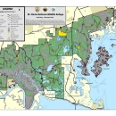
Maps of the St. Marks showing roads and trails.
Other Facilities in the Complex
St. Marks NWR is managed as part of the North Florida Refuges Complex. A National Wildlife Refuge Complex is an administrative grouping of two or more refuges, wildlife management areas or other refuge conservation areas that are primarily managed from a central office location. Refuges are grouped into a complex structure structure
Something temporarily or permanently constructed, built, or placed; and constructed of natural or manufactured parts including, but not limited to, a building, shed, cabin, porch, bridge, walkway, stair steps, sign, landing, platform, dock, rack, fence, telecommunication device, antennae, fish cleaning table, satellite dish/mount, or well head.
Learn more about structure because they occur in a similar ecological region, such as a watershed or specific habitat type, and have a related purpose and management needs. Typically, a project leader or complex manager oversees the general management of all refuges within the complex and refuge managers are responsible for operations at specific refuges. Supporting staff, composed of administrative, law enforcement, refuge manager, biological, fire, visitor services, and maintenance professionals, are centrally located and support all refuges within the complex.
The North Florida National Wildlife Refuge Complex encompasses the St. Marks National Wildlife Refuge and the St. Vincent National Wildlife Refuge and associated conservation easements across 13 counties in southwestern Georgia and the Florida panhandle protecting close to 95,000 acres for wildlife. The addition of Lower Suwannee National Wildlife Refuge and Cedar Keys National Wildlife refuges unifies our national wildlife refuges along Florida’s “Big Bend” or “Nature Coast,” which is one of the largest, undeveloped, mostly privately-held coastal areas in the nation.
Rules and Policies
There are lots of fun, interesting, and educational things you can do on the refuge. Keep in mind, if an activity is not wildlife related and doesn’t help in the protection or understanding of wildlife or their habitat, there are probably refuge rules governing this activity. Please check with the refuge management before participating in an activity that could harm the environment or yourself. There are plenty of activities on St. Marks NWR for you to enjoy. Be safe and have fun!
ALL federal, state, and local laws and regulations are applicable on Refuge System lands and waters.
Refuge open year round during daylight hours (gate on Lighthouse Road opens at 6 am).
Observe posted speed limits.
Pets on leash allowed.
Collecting or taking of artifacts, natural features, animals or plants on government property is prohibited.
Please do not litter.
Boats are allowed in refuge pools, March 15 through October 15, however only non-motorized boats or boats with electric motors are allowed.
Drones are prohibited.
Crabbing in refuge pools and ponds is prohibited.
No swimming.
Administrative roads and levees may be closed during prescribed burns, peak wildlife events, especially around eagle nests, shorebird and waterfowl areas. Please check with the Visitor Center, +1 850-925-6121, for the latest information concerning closures.
To learn more about hunting opportunities, seasons and regulations on the St. Marks NWR, contact the refuge office at +1 850-925-6121.
Locations
The Refuge's Visitor Center and administrative office is located about 25 miles south of Tallahassee, FL. From Tallahassee, take SR 363 (Woodville Hwy) to Wakulla. Turn left (east) on SR 267 (Bloxham Cutoff). At US 98 (Coastal Hwy), turn left (east) and cross the St. Marks River. Turn right on Lighthouse Road (CR 59) and drive 3 miles to the Visitor Center/Office.